• Can Climate Proofing Structures Help Reverse Climate Change?

    This story was originally published by on the Bluebeam Blog.

    With the built environment such a prominent source of carbon emissions, it is vital that the industry recognizes the urgent need to ‘climate proof’ homes and other built assets and infrastructure.

    Everyone is aware of the potentially catastrophic consequences of climate change. Climate change has been exacerbated by human activity, particularly since industrial activity increased dramatically in the 1800s. The burning of fossil fuels such as coal, oil and gas generates greenhouse gas emissions, effectively trapping the sun’s heat and raising temperatures around the world.

    Responding to the looming crisis, international governments have pledged to lower carbon emissions to reduce global warming. Only last month negotiators from dozens of countries agreed to shift away from fossil fuels at the COP 28 climate summit.

    Yet as the United Nations (UN) points out, rising temperatures are just the start.

    “The consequences of climate change now include, among others, intense droughts, water scarcity, severe fires, rising sea levels, flooding, melting polar ice, catastrophic storms and declining biodiversity,” it says.

    Eliminate carbon emissions from buildings

    The built environment is stepping up and playing its part in reducing carbon emissions. Since construction activity and building occupation accounts for around 39% of global carbon emissions, the pressure is on designers, developers, building owners and operators, and occupiers to make buildings greener.

    There is much work to do. A report called “UK Housing: Fit for the Future?,” published in 2019 by the UK government’s advisory Committee on Climate Change (CCC), argued that the UK’s legally binding climate change targets would not be met “without the near-complete elimination of greenhouse gas emissions from UK buildings.”

    The CCC’s report noted that efforts to reduce emissions from the UK’s 28 million or so homes had stalled, while domestic energy use—which accounted for 14% of total UK emissions—had increased. Worryingly, efforts to adapt the UK’s housing stock to the impacts of the changing climate—known as climate proofing—were “lagging far behind what is needed to keep us safe and comfortable, even as … climate change risks grow.”

    So how can the UK’s building stock, and particularly homes, be climate proofed?

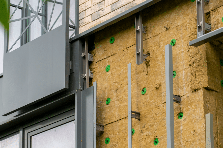
    There are two approaches: First, when building new, do so to exacting standards that lower their environmental impact; second, retrofit existing buildings with materials and technologies to the same end.

    Build in weather resistance

    The UN’s Environment Programme (UNEP) says it is possible to build in resistance to heatwaves, extreme cold, cyclones and strong winds, coastal flooding and drought with a variety of construction strategies.

    “Structural designs can help reduce heat inside buildings,” the UNEP says. “In Vietnam, traditional housing designs such as the optimum orientation of buildings, high-rise rooms and large openings improve ventilation.”

    “Walls of concrete, stone or other heavy material that capture solar heat are used in China, Chile and Egypt. Green roofs and reflective surfaces can also reduce temperatures in and around buildings.”

    The UNEP says that adapting to cold and temperate climates “requires capturing heat and minimizing heat loss. Insulations in roofs, walls, ceilings and double-glazed windows help to minimize heat loss and lead to more energy-efficient buildings.”

    To resist the effects of strong winds, homes could be built in circular shapes, while strong connections between foundations and the roof are critical to building wind-resilient houses.

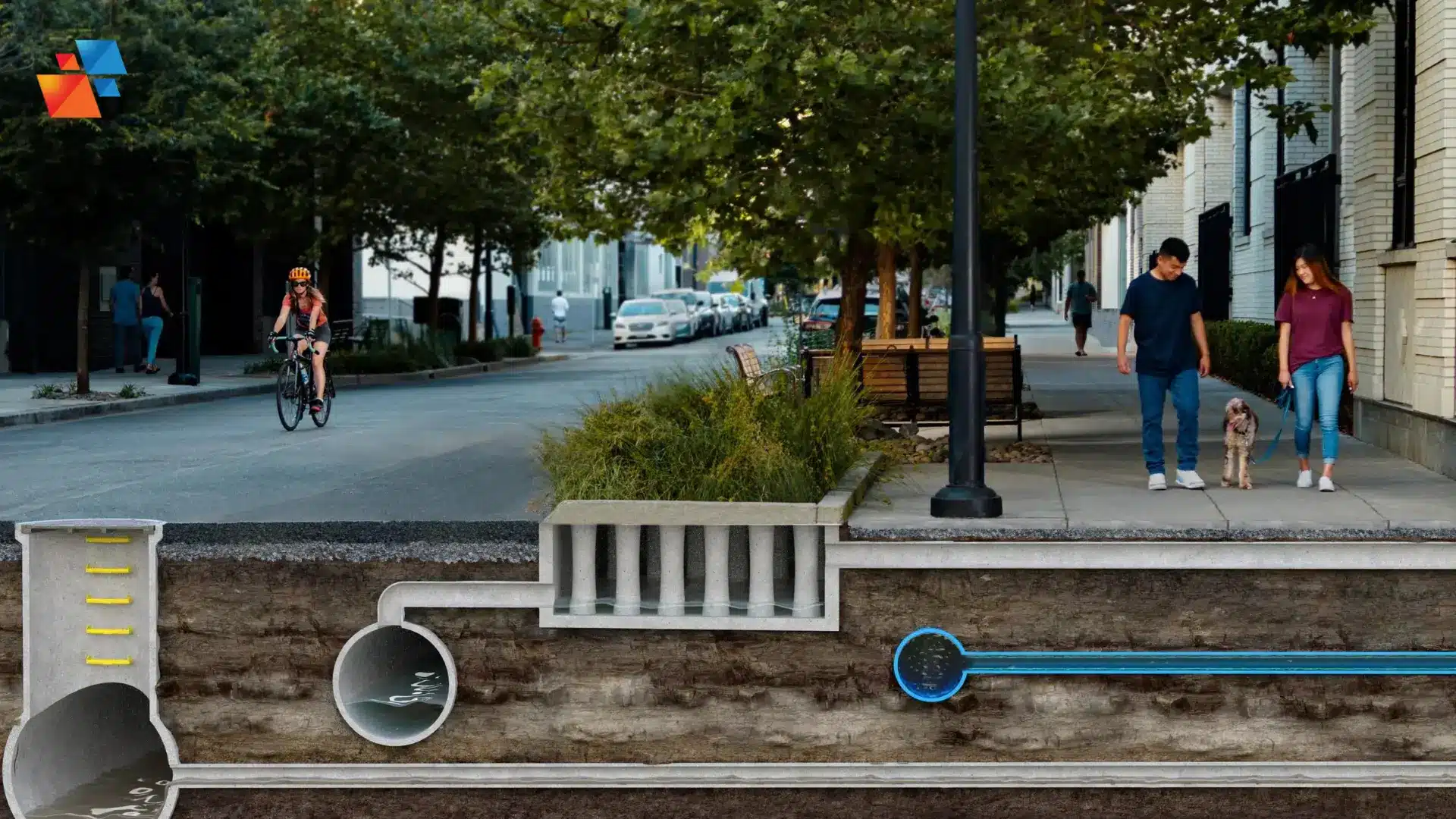
    Homes built in areas at risk of flooding could be positioned on pillars to allow floodwater to flow underneath, the UNEP suggests, while those in drought-affected regions could feature rainwater harvesting and recharge systems that capture water on the roofs of buildings.

    Passivhaus technology

    Companies have been working on climate-proof building concepts for years. Perhaps the most familiar example is the Passivhaus program. Developed in Germany in the late 1990s, key features of a Passivhaus are lots of insulation and airtightness, minimal thermal bridging, optimization of passive solar gain, mechanical ventilation with heat recovery and a simple, compact shape.

    According to the International Passive House Association, which promotes the Passivhouse Standard, along with “a greater public understanding of highly energy-efficient buildings,” such homes need just 10% of the energy used by typical Central European buildings.

    A disadvantage, at least in the short term, is that a Passivhaus costs around 8% more upfront to build, says the IPHA. But a house built this way eventually uses much less energy than a conventional new home, meaning over time this kind of outlay will be recouped; plus, there’s the improved comfort and structural performance to consider.

    We understand the sort of elements that should go into a newly built home. Let’s assume that new UK homes are being consistently built to high climate change-resistant standards and housebuilders lay claim to buyers making significant energy savings when acquiring “new.” The next question is what to do about existing homes?

    Given the age of most of the UK’s existing housing stock, this is an issue that needs tackling. More than half of the country’s homes were built before 1965, more than a third before 1945 and 20% prior to 1919. Just 7% has been delivered since 2000.

    Retrofitting homes—the costly solution

    Retrofitting has been put forward as the best solution. But given the number of households in the UK, around 28 million, the scale of the task is positively Herculean. The cost is not insignificant either.

    According to a study by the University of Nottingham, the cost of “deep retrofit”—effectively retrofitting a home to the highest levels of energy efficiency—is expected to average around £69,000, or $86,850, more than twice the government estimate for such work. So carrying out such retrofits on every older home in the country will come with a high cost.

    In addition, there is the time it will take to retrofit so many homes. But not doing anything isn’t an option, which the industry recognizes.

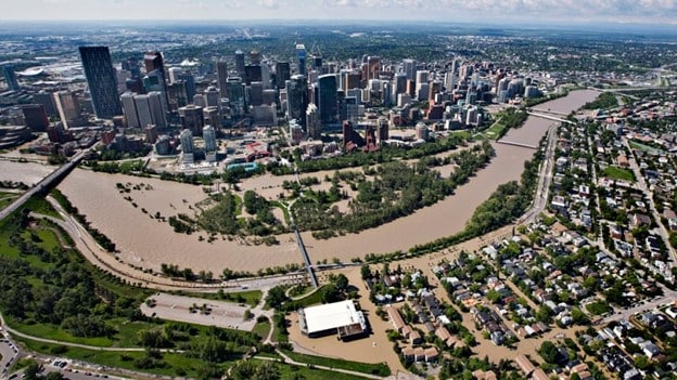
    Infrastructure is another area where climate proofing is vital so services can continue to function in the event of things like catastrophic flooding.

    According to the OECD, “ensuring that infrastructure is climate resilient will help to reduce direct losses and reduce the indirect costs of disruption,” which can result from the same factors that threaten the viability of so many homes across the country.

    Mastering Point Clouds in Civil 3D: A Three-Part Guide to Efficiency: Bonus Part

    This is a bonus article in the Point Cloud series. Click to view: 

    Article 1 

    Article 2 

    Article 3 

    With all this talk about decimation and removing many of those original points in the cloud, how does one know if they’ve removed too many points? Here is how I do it. 

    • Insert the point cloud into Civil 3D.
    • Make a surface from the original point cloud, but only a small subset, so it’s not too big.

    • Make a surface from the decimated classification using the same red border as above. This so you can tell how many points are used for each surface within that area. 
    • Make an alignment and profile sampling both surfaces and have a look. The blue is the original, the red is the decimated cloud. Some of it is bang on and some of it isn’t. You get to decide if you have decimated too much.

    Are there any other ways to decimate that are better? VRMESH and Pix4D are expensive applications that do this, but I have limited experience with them. Civil 3D, however, has one more trick up its sleeve. 

    • Make a new surface and paste the original point cloud surface into it. Yes, the big one, but remember that it’s only using the points within the red border. 
    • Use the Simplify Surface editing tool. The highlighted number is where you can experiment. The bigger the number, the more points will be removed.

    • Sample this new surface in the profile view with the other 2 and compare. The purple profile was created with this new surface. That surface contains about the same number of points as the one created using the decimated cloud from Recap. It is closer to the original.

    What does this mean? Is Civil 3D’s Simplify Surface tool better than Recap’s “Intelligent Decimation”? In my experience, I find that yes, it can give me a better result. But not always. Even in this same dataset, there are areas where the decimated cloud is closer to the original. The red line below. 

    Here is my philosophy. This works best for me. Your mileage may vary depending on your point cloud. 

    1. If a cloud has 80 million points, it is more efficient to decimate it using Recap before it ever comes into Civil 3D. 
    1. Decimate in Recap, but maybe not as much as you would like. E.g., if I think  1 million points is the right number for my Civil 3D surface, I will decimate to 2 or 3 million. 
    1. After modeling the surface, use the Simplify tool to get the surface down to that 1-million-point mark, or whatever your intended number is. 

    Click here to download the sample files. 

    HIVE Revit Family Standards

    What are HIVE Revit Family Standards?

    HIVE Standards is a system that helps BIM managers check and maintain the quality of Revit family content for the organization. It is set up in the HIVE Portal and runs automatic checks on the content in chosen libraries. It can also be modified to fit the organization’s own standards.

    Qualified content in a library has the checks performed. If you have 500 items in a library, there may be only 100 items that qualify.

    What qualifies a piece of content?

    • families of versions greater than Revit 2020
    • families that can exist outside of a Revit project model
    • families that have not been automatically upgraded (checks the source version only)

    Configuring Family Standards

    Access Family Standards by logging into the CTC HIVE Portal.


    HIVE Standards

    Select the “Standards” tab and select the “Family Ruleset” on the left side bar.

    HIVE Standards

    Select the applicable settings to be used for checks.

    HIVE Standards

    • Include Shared Parameter Use in Automated Rating: if a shared parameter file has been uploaded to HIVE, it will be used in this check
    • Include Custom Parameter Use in Automated Rating: checks for parameters not typically found in families (such as built-in parameters)
    • Include Custom Parameter Naming in Automated Rating: checks that custom parameters meet the established naming rules
    • Include Parameter Grouping in Automated Rating: checks that parameter groups follow established rules

    HIVE Standards

    • File Size: set a maximum size for the family file and include it in the rating

    HIVE Standards

    • Include Mapping in Automated Rating: check that the mapping used follows established standard
    • Include Unused in Automated Rating: check if there are unused sub-categories

    HIVE Standards

    • Reference Plane Naming in Automated Rating: check if the reference planes are named according to established standard

    HIVE Standards

    • Exclude Public Content with Combined Rating Less than Minimum: content from public libraries rated below this threshold will not be shown in search results
    • Exclude Org Content with Combined Rating Less than Minimum: content rated below this threshold will not be shown in search results

    Along with the Family Ruleset settings, additional options with the Common Standards can be applied. Common Standards are organization specific standards that apply to both projects and families. To access the Common Standards, in the left side bar select Common Standards.


    HIVE Standards

    Configuring Common Standards

    • You can upload your organizations Shared Parameter file to be used for various features within standards such as family checking.
    • You can use Parameter Grouping to establish valid parameter groups to be used with standards, select it from the left tree and use the arrow to add it to the right.
    • In addition to the Common Standards, you can set Parameter Name Rules and Custom Sub-Categories
      • Valid Parameter Name Parts: put valid parts of names that should be used when naming parameters. ie. ARCH E_ LC-
      • Invalid Parameter Name Parts: combinations of letters and symbols of names that should not appear in parameter names.

    Running Family Standard Checks

    Select the libraries you want from the organization list by ticking the boxes next to them. A green button will show up on the top right corner of the list when you do that. Press this button to start the process.

    HIVE Revit Family Standards

    • The checking process runs silently, without requiring any input from the user.
    • A scoring process is used during the check (Ex: Identity Data, MEP Connectors, Warnings etc.) to validate the content against the Family Standards settings (Family Ruleset and Common Standards).
    • You will receive a email with the review results and have the ability to download a Excel file that consists of all the results from the checks.
    • You can access and review the data in multiple ways.
    • Directly using the Excel spreadsheet, leveraging PowerBi and utilizing the WebAPI are a few examples.
    • For more information on CTC HIVE Family Standards visit www.ctcsoftware.com.

    For any questions reach out to your sales rep or contact us at info@solidcad.ca.

    Bug des Points COGO entre Civil 3D 2024.3 et Windows français

    Au Québec, il est très courant d’installer Windows avec des préférences régionales « francophones » par défaut, comme une « , » pour symbole de décimale et un « ; » comme séparateur de listes, ce qui peut mener à un conflit avec plusieurs applications dans Civil 3D 

    Nature du problème

    Depuis la version 2024.3, Civil 3D lit maintenant ce choix de symboles dans les préférences de Windows pour les utilisés dans la condition d’inclusion des groupes de points « par numéro », utilisée constamment lors de l’importation de points à partir d’un fichier ASCII (CSV, TXT, etc.). Civil 3D écrit toutefois le groupe de point COGO comme si la « , » était encore le symbole « ET », mais Windows francophone ne le reconnait pas.

    Donc, si vos paramètres régionaux sont francophones et que le symbole de séparateur de liste n’est pas encore changé dans Windows (en français), le symbole “,” ne sert à rien.

    Exemple : Dans le cas suivant, le groupe arrête de lire les points passé la première virgule, et n’inclura donc seulement que les points entre les numéros 1000 et 1018.

    Ceux qui ont Windows en anglais n’ont pas ce trouble, comme c’est un setting “régional”. 


    La solution 

    En attendant d’avoir une solution officielle fournie par Autodesk, il faudra changer la préférence des caractères dans Windows pour avoir « , » comme séparateur de liste officiel. Voici les étapes pour y arriver. 

    1. Aller dans les Paramètres Windows è section Région et cliquer le lien Date, heure et paramètres régionaux supplémentaires. 
    2. Cliquer sur Modifier les formats de date, d’heure ou de nombre. 

           3. Cliquer sur le bouton Paramètres supplémentaires. 


           4. Changer le symbole de décimal de « , » à « . », et changer le symbole de séparateur de listes de « ; » à « , ».

    En redémarrant Civil 3D, le problème sera réglé! 


    Mastering Point Clouds in Civil 3D: A Three-Part Guide to Efficiency: Part 3

    Most survey and design firms these days rely on point cloud data to some degree. It is often faster, easier, and safer to survey using aerial or ground-based scanners compared with traditional survey methods. 

    “But these clouds clog up my Civil 3D drawing when I make a surface.” You say. I’m here to tell you that they don’t have to! The dataset is always huge, tens or even hundreds of millions of points. When the deliverable is a surface model in Civil 3D, 3 things must happen. 

    This is the third and final in a series of three articles outlining how Autodesk Recap and Civil 3D are used to carry out these tasks. Click here for the first article in this series. Click here for the second. 

    Task 3: Import to Civil 3D and model a surface. You may already know this step, but since Recap has been used to classify and decimate the points, there is a new task in Civil 3D. 

    Once the point cloud has been attached, all the points will show, and it seems logical to go here and ensure that ONLY the decimated points (Key) are visible so we can model the surface using only those points. 

    Yes, only the Key points are visible, but when we try to model the surface, Civil 3D is using all 15 million of them, not the 10,000 that was specified during the decimation process. Autodesk is aware of this “defect”. When or if it will be rectified is unknown. 

    But don’t fret, there is a workaround. 

    Turn on the map Workspace (MAPWPACE) and create a new layer from the point cloud. 

    Filter the Key points in that new layer. 

    Then create the surface normally. Only the Key points will be used. 

    Stay tuned for the BONUS article… Yes, you read that right. There is one more. 

    a percée d’Innovyze dans la gestion des eaux urbaines : Ouvrir la voie à des villes résilientes aux inondations

    Introduction

    Les inondations urbaines représentent un défi important dans notre monde qui s’urbanise rapidement. À mesure que les villes s’étendent et que le climat évolue, les conséquences des inondations dans les zones urbaines deviennent de plus en plus graves, affectant les infrastructures, les écosystèmes et la santé publique. Ce blog examine comment des solutions innovantes comme celles d’Innovyze transforment le paysage technique de la gestion des inondations et de l’eau en milieu urbain, en offrant de l’espoir et des solutions pratiques à ces problèmes urgents.

    Urban Flood Management

    Calgary, Alberta. June 2013

    Gestion des inondations urbaines : La marée montante

    Les inondations urbaines, une préoccupation croissante dans de nombreuses villes, sont exacerbées par le changement climatique et l’urbanisation rapide. Les stratégies traditionnelles de gestion des inondations, bien que toujours utilisées, sont aujourd’hui complétées par des technologies de pointe. Innovyze est à l’avant-garde de cette révolution technologique dans la gestion des inondations urbaines. Leur suite d’outils, comprenant InfoDrainage et InfoWorks ICM, offre une approche complète de la prévision et de la gestion des inondations urbaines. Ces outils utilisent la modélisation hydraulique et l’intelligence artificielle pour simuler des scénarios d’inondation avec précision, ce qui permet aux villes de planifier et de mettre en œuvre des mesures efficaces de lutte contre les inondations.

    Ces systèmes avancés permettent non seulement de prédire où ira l’eau en cas d’inondation, mais aussi de placer intelligemment des dispositifs de contrôle des eaux pluviales tels que des chambres et des étangs. L’introduction de l’IA dans des outils tels que la fonction Machine Learning Deluge d’InfoDrainage représente une avancée significative. Il permet aux modélisateurs de simuler des inondations à l’aide d’un algorithme d’intelligence artificielle, ce qui leur permet de prendre des décisions éclairées et intelligentes lors de la phase de conception, ce qui est essentiel pour gérer efficacement les inondations urbaines.

    Planifier à contre-courant : La prévention des inondations par l’aménagement urbain

    La planification urbaine joue un rôle essentiel dans l’atténuation des risques d’inondation. En intégrant des stratégies de prévention des inondations dans la conception des villes, les urbanistes peuvent réduire de manière significative l’impact des inondations. Les stratégies clés comprennent l’utilisation d’infrastructures vertes, telles que les parcs et les zones humides, qui absorbent et gèrent naturellement les eaux de ruissellement. Les surfaces perméables dans les zones urbaines, comme les chaussées poreuses, jouent également un rôle crucial en permettant à l’eau de s’infiltrer dans le sol, réduisant ainsi le ruissellement et la pression sur les systèmes de drainage.

    Des études de cas réalisées dans différentes villes démontrent l’efficacité de ces stratégies. Par exemple, l’utilisation de toits verts, de jardins de pluie et d’égouts biologiques dans les zones densément peuplées permet non seulement d’atténuer les risques d’inondation, mais aussi de renforcer la biodiversité urbaine et d’améliorer la qualité de l’air. La technologie d’Innovyze, notamment InfoDrainage, a joué un rôle déterminant dans la conception et la mise en œuvre de ces stratégies de planification urbaine, en veillant à ce qu’elles soient à la fois efficaces et durables.

    Urban Flood Management

    L’effet d’entraînement : Le rôle crucial de la gestion des eaux urbaines

    Une gestion efficace des eaux urbaines est essentielle pour la durabilité des écosystèmes urbains et la santé publique. Un système d’eau urbain équilibré comprend non seulement l’approvisionnement en eau propre, mais aussi des systèmes de drainage efficaces pour prévenir les inondations et gérer les eaux pluviales. Cet équilibre est essentiel pour préserver la santé des environnements urbains et garantir le bien-être des citadins.

    Une mauvaise gestion des services publics peut entraîner toute une série de problèmes, notamment la pollution de l’eau, la destruction de l’habitat et l’augmentation des risques sanitaires dus aux inondations et aux maladies transmises par l’eau. Les outils avancés d’Innovyze, comme InfoDrainage et InfoWorks ICM, aident les urbanistes et les ingénieurs à concevoir de meilleurs systèmes de drainage qui gèrent durablement les eaux pluviales et les déchets, contribuant ainsi à la résilience globale des villes face au changement climatique et aux défis de l’urbanisation.

    Innovyze flood modeling

    Vers un avenir durable : L’approche d’Innovyze en matière de gestion des eaux urbaines

    Innovyze est à l’avant-garde des pratiques de gestion durable des eaux urbaines. Leur approche intègre à la fois des solutions traditionnelles et innovantes, en se concentrant sur la santé et la résilience environnementales à long terme. La suite d’outils d’Innovyze, dont InfoDrainage, incarne cette philosophie durable, permettant aux urbanistes et aux ingénieurs de concevoir des systèmes d’approvisionnement en eau qui soient à la fois efficaces et respectueux de l’environnement.

    Les pratiques durables en matière de gestion de l’eau impliquent l’utilisation d’infrastructures vertes, telles que les jardins de pluie et les toits verts, qui absorbent et réduisent naturellement la quantité d’eaux pluviales devant être gérées en aval dans le système de gestion des eaux pluviales. La technologie d’Innovyze permet d’intégrer ces éléments dans la planification urbaine, en veillant à ce qu’ils soient à la fois esthétiques et fonctionnels. InfoDrainage, par exemple, aide à concevoir des systèmes qui gèrent efficacement les eaux pluviales tout en minimisant l’impact sur l’environnement.

    En outre, les outils d’Innovyze sont conformes aux principes des systèmes de drainage durable (SDD), qui sont de plus en plus adoptés dans le monde entier. Les systèmes d’adduction d’eau visent à gérer l’eau de manière à imiter les processus naturels, en incorporant des éléments tels que des surfaces perméables et des zones humides dans les paysages urbains. Ces pratiques contribuent non seulement à la prévention des inondations, mais elles renforcent également la biodiversité urbaine et améliorent la qualité de vie dans les zones urbaines.

    Conclusion

    Les défis posés par les inondations urbaines et la gestion de l’eau exigent des solutions innovantes. La technologie révolutionnaire d’Innovyze offre une lueur d’espoir à cet égard. Leur suite d’outils, dont InfoDrainage et InfoWorks ICM, révolutionne la façon dont les inondations urbaines et la gestion de l’eau sont abordées, en associant les pratiques traditionnelles à la technologie de pointe. Alors que nous nous dirigeons vers la construction de villes plus durables et plus résistantes, le rôle des technologies telles que celles proposées par Innovyze devient de plus en plus crucial.

    La mise en œuvre de ces solutions ne se limite pas à la gestion de l’eau ; il s’agit de créer des environnements urbains plus sains et plus durables pour les générations futures. Nous encourageons les discussions et les actions au sein des communautés et des décideurs politiques afin d’explorer et de mettre en œuvre ces solutions innovantes.

    Innovyze’s Breakthrough in Urban Water Management: Paving the Way for Flood-Resilient Cities

    Revolutionize your approach with Innovyze Explore our exclusive landing page now.

    Introduction

    As cities continue to expand, the importance of ‘Flood Resilience’ in our urban spaces has never been more critical. In the face of shifting climate patterns and urban growth, managing water in these areas is a daunting task. This blog focuses on ‘Urban Water Management’ and how it’s integral to mitigating the severe impacts of flooding in densely populated regions. We highlight the role of ‘Innovyze Flood Modeling’ technology in transforming the approaches to urban flood and water management. By harnessing these innovative solutions, cities are finding new ways to turn the tide against the challenges of urban flooding, offering hope and effective strategies to preserve infrastructure, ecosystems, and public health.

    Urban Flood Management

    Calgary, Alberta. June 2013

    Urban Flood Management: The Rising Tide

    Urban flooding, a growing concern in many cities, is exacerbated by climate change and rapid urbanization. Traditional flood management strategies, while still in use, are now being augmented by advanced technology. Innovyze stands at the forefront of this technological revolution in urban flood management. Their suite of tools, including InfoDrainage and InfoWorks ICM, offers a comprehensive approach to predicting and managing urban floods. These tools utilize hydraulic modeling and AI to simulate flood scenarios with precision, enabling cities to plan and implement effective flood control measures.

    These advanced systems not only predict where the water will go in flood scenarios but also allow for the intelligent placement of stormwater controls like chambers and ponds. The introduction of AI in tools like the Machine Learning Deluge feature in InfoDrainage represents a significant leap forward. It enables modelers to simulate flooding events with an AI algorithm, allowing them to make informed and intelligent decisions in the design phase that are crucial in managing urban flooding effectively.

    Planning Against the Current: Flood Prevention through Urban Design

    Urban planning plays a pivotal role in mitigating the risks of flooding. By incorporating flood prevention strategies into city design, urban planners can significantly reduce the impact of flooding events. Key strategies include the use of green infrastructure, such as parks and wetlands, which absorb and manage stormwater naturally. Permeable surfaces in urban areas, like porous pavements, also play a crucial role by allowing water to seep into the ground, reducing runoff and the strain on drainage systems.

    Case studies from various cities demonstrate the effectiveness of these strategies. For example, the use of green roofs, rain gardens, and bioswales in densely populated areas not only mitigates flood risks but also enhances urban biodiversity and improves air quality. Innovyze’s technology, including InfoDrainage, has been instrumental in designing and implementing these urban planning strategies, ensuring they are both efficient and sustainable.

    Urban Flood Management

    The Ripple Effect: The Crucial Role of Urban Water Management

    Effective urban water management is essential for the sustainability of city ecosystems and public health. A balanced urban water system encompasses not only the supply of clean water but also efficient drainage systems to prevent flooding and manage stormwater. This balance is vital in maintaining the health of urban environments and ensuring the well-being of city inhabitants.

    Poor utilities management can lead to a host of problems, including water pollution, habitat destruction, and increased health risks due to flooding and waterborne diseases. Innovyze’s advanced tools, like InfoDrainage and InfoWorks ICM, help urban planners and engineers design better drainage systems that sustainably manage both storm water and waste, contributing to the overall resilience of cities against climate change and urbanization challenges.

    Innovyze flood modeling

    Towards a Sustainable Tomorrow: Innovyze’s Approach to Urban Water Management

    Innovyze is at the forefront of advancing sustainable urban water management practices. Their approach integrates both traditional and innovative solutions, focusing on long-term environmental health and resilience. Innovyze’s suite of tools, including InfoDrainage, embodies this sustainable philosophy, enabling urban planners and engineers to design water systems that are effective as well as environmentally friendly.

    Sustainable practices in water management involve the use of green infrastructure, such as rain gardens and green roofs, which naturally absorb and reduce the amount of stormwater than needs to be managed further down the in the SWM system. Innovyze’s technology allows for the integration of these elements into urban planning, ensuring that they are both aesthetically pleasing and functionally effective. InfoDrainage, for example, aids in designing systems that effectively manage stormwater while minimizing the impact on the environment.

    Moreover, Innovyze’s tools align with the principles of sustainable drainage systems (SuDS), which are increasingly being adopted worldwide. SuDS aims to manage water in a way that mimics natural processes, incorporating elements like permeable surfaces and wetlands into urban landscapes. These practices not only help in flood prevention but also enhance urban biodiversity and improve the quality of life in urban areas.

    Conclusion

    The challenges of urban flooding and water management demand innovative solutions. Innovyze’s breakthrough technology offers a beacon of hope in this regard. Their suite of tools, including InfoDrainage and InfoWorks ICM, revolutionize the way urban flooding and water management are approached, blending traditional practices with cutting-edge technology. As we move towards building more sustainable and resilient cities, the role of technologies like these offered by Innovyze becomes ever more critical.

    Engaging with these solutions is not just about managing water; it’s about creating healthier, more sustainable urban environments for future generations. We encourage discussions and actions among communities and policymakers to further explore and implement these innovative solutions.

    Nouveautés CIM Project Suite 24.0 à 24.4

    La version 24 et ses mises à jour subséquentes contiennent beaucoup d’ajouts et améliorations à vos outils. L’article suivant vous orientera sur les changements les plus significatifs pour vous et votre équipe. 

    Auto Grader 

    Amélioration : Ajout d’une colonne de dernière exécution au formulaire principal avec la date et l’heure qui sont mises à jour chaque fois qu’une famille est exécutée. 

    Amélioration : Ajout d’un bouton permettant de zoomer et de mettre en surbrillance le niveau de la famille sur le formulaire principal ou le niveau enfant dans le formulaire de la famille. 

    Amélioration : Les paramètres de surface en sortie sont désormais contrôlés à partir du formulaire de famille et sont beaucoup plus détaillés, y compris des options de bordure et une sélection granulaire des lignes caractéristiques du terrain de la famille à ajouter en tant que lignes de rupture dans la surface. 

    Amélioration : Ajout de la possibilité de créer une ligne caractéristique du terrain enfant qui sera étalée des deux côtés. La fonctionnalité est similaire à celle de la commande native INSERTFEATUREHIGHLOWPOINT, mais suppose que les points de départ et d’arrivée sont simplement les premiers et derniers sommets de la ligne caractéristique du terrain et ne seront disponibles que lors de l’utilisation de l’option de talus existante. 

    Amélioration : Ajout d’une méthode à la famille perpendiculaire et à la pente existante qui permettrait de trouver le point haut ou le point bas d’une ligne caractéristique du terrain sélectionnée à une pente donnée, similaire à la commande INSERTFEATUREHIGHLOWPOINT. 

    Amélioration : Ajout de la possibilité de créer des lignes de rupture de surface lors de la sélection de lignes caractéristiques du terrain en tant que parents sans qu’aucune ligne caractéristique du terrain enfant ne soit créée. 

    Amélioration : Ajout de la possibilité de sélectionner des segments de parcelle à partir du composant de filtre de lignes caractéristiques du terrain parent lors de la création de familles de talus perpendiculaires et de talus existants. 


    Clash Seeker 

    Nouvelle fonctionnalité : nouvel outil permettant de rechercher et de signaler les conflits de proximité pour les entités de dessin.  

    La liste des objets analysables comprend : 

    • Axe; 
    • Blocks; 
    • Lignes caractéristiques; 
    • Lignes et arcs; 
    • Segments de parcelles; 
    • Points COGO et topographiques; 
    • Polylignes 2D et 3D; 
    • Solides;
    • Surfaces; 
    • Figures topographiques; 
    • Réseaux de canalisation gravitaires; 
    • Réseaux de canalisation sous-pression; 

    Label Genie 

    Amélioration : Ajout d’une zone de sélection pour supprimer toutes les étiquettes lorsque des objets d’ancrage similaires sont sélectionnés. 

    Amélioration : Ajout de points de surface sur la sélection de grille pour étiqueter les altitudes dans des limites de région sélectionnées spécifiques. 

    Amélioration : Implémentation de méthodes de sélection d’objets courantes. 

    Pipe Designer 

    Amélioration : Ajout d’un bouton permettant d’inverser l’ordre de sélection des tuyaux sans avoir à entrer dans le dessin. 

    Avant l’inversion sur toute la sélection : 

    Après l’inversion sur toute la sélection : 

    Construction-Themed Amusement Park Aims to Inspire Kids to Join the Industry

    This story was originally published by  on the Bluebeam Blog.

    Diggerland in New Jersey hopes to expose kids to the thrills of working in the construction industry.

    Making construction appealing to the next generation is critical to helping the industry overcome a significant worker shortage. It’s also the central idea behind Diggerland, USA, the nation’s first full-fledged construction-themed amusement park and waterpark in West Berlin, New Jersey.

    Diggerland features real-life construction equipment that has been made safe for children and adults to operate and explore. The rides are designed specifically for the park, with safety features that make it appropriate for young children.

    Diggerland’s CEO, Yan Girlya, and his brother, Ilya Girlya, worked in the construction industry for 30 years, learning the ropes from their parents, who owned a construction business that focused on public works and schools. After graduating from Drexel University, Yan worked for the company as a superintendent, progressing to project manager and, eventually, general manager. Because of the state of the economy and other factors, the brothers decided to close down the construction company and focus on entertainment.

    “In the early 2000s, when we joined the union, we started our own civil division in the company, and we bought heavy equipment. As the downturn of the economy happened, we saw less and less work on our end,” Yan said. Believing that they couldn’t compete against larger equipment rental companies, they started exploring where else they could put this machinery to use.

    Inspiration from abroad

    The brothers came across several Diggerland theme parks in the United Kingdom. They thought if it worked across the pond, it should be an easy transition to bring it to America.

    “We reached out to that owner, and it took us literally two years for him to convince us to work with him to bring it to the United States,” Yan said. Even though the economy wasn’t great at the time, “we decided to take a chance because that is what we do as entrepreneurs: we plow ahead.”

    Though there have been several other construction-themed amusement parks since Diggerland USA opened in 2014, at the time there was nothing like it in America.

    The brothers saw New Jersey—their home state—as a natural fit for the park so they could work on the business hands on. They already owned an indoor water park in West Berlin, so when an adjacent parcel of land became available, they bought it.

    The brothers originally used the construction equipment from their former construction business to create Diggerland XL. “Diggerland XL was a one-one-one experience using large excavators, dozers and wheel loaders for an adult experience. This program ended in 2022 to make room for an expansion,” Yan said. That year, they doubled the size of the water attractions and added more amusement rides. To date, the park contains more than 40 attractions.

    All of the features in Diggerland include brand-new, special-ordered equipment. The goal was to replicate the same functions with all of the attractions. All of the machines have hydraulic and/or electronic limiters that provide for safe operation. In certain equipment, if one system fails, there is a second system that automatically takes over.

    One of the newest attractions is the Lumberjack Claw, a hydraulically driven log loader machine that, in the real world, handles timber before it goes to the mill. Children can operate the rig with a joystick to simulate how this machine functions on an actual construction site. “We modified this ride where anyone can use it,” Yan said. “We worked with our local mechanical engineers to make it safe and did testing. They ran calculations and made a foundation for the unit. Months later, it was set in place, and we worked with a hydraulic manufacturer to make a custom-made hydraulic pack unit.”

    In addition to the well-received Lumberjack Claw, one of the most popular attractions is the Spin Dizzy, a 48,000-pound excavator with a custom-made bucket that seats eight people. “When the customer enters the gondola, each one puts on a seat belt as well as a lap bar. Once everyone is secure in their seats, the ride operator raises the boom and arm of the excavator and rotates the machine five times in one direction and then five times in the opposite direction. Hence the name Spin Dizzy,” Yan said.

    Other rides include Crazy Cranes, enabling children to use a tower crane from the ground level, with the ability to move objects with joystick controls, as well as the Mini Dig, allowing children to use the arm of a JCB 8018 mini-excavator with a hook to pick up shapes and drop them into matching holes.

    Inspiring kids

    Even the water park, The Water Main, is construction themed. It includes two pools, Bulldozer Bay and Jackhammer Bay, with water spraying through jackhammers; a zero-depth entrance wave pool, Claw Hammer Cove; and a three-story body slide, The Pipeline, with closed and open flumes. An obstacle course pool, Carpool Lane, has construction lily pads, a mesh crossing rope and overhanging water cranes.

    One of the biggest challenges the brothers faced when recreating Diggerland from the original UK version were differences in rules and safety regulations between countries. “What was done in the UK and is done in the US is day and night,” Yan said.

    It was also difficult adhering to state regulations. For each ride, they hired third party crash engineers to ensure the equipment is safe. “Our machines are limited to four ,five miles an hour, so the engineers come out and take our vehicle to verify the impact on the human body,” Yan said. This data is then submitted to the state of New Jersey, which will grant permits once approved.

    By pairing amusement with construction, one of the underlying goals of this park was to introduce construction equipment to children in a fun way that might inspire them or plant a seed for a future career. Despite the male-dominated construction industry, Yan said about 40% of park attendees are girls. In addition to introducing children to construction equipment—and, by extension, the construction industry—it teaches and enhances hand-and-eye coordination. Yan said, “Driving the machines is thrilling while providing a sense of direction and full control. It gives younger kids a hands-on experience and a boost of confidence that they, too, can do it just like the people who operate the equipment for a living.”

    Mastering Point Clouds in Civil 3D: A Three-Part Guide to Efficiency: Part 2

    Many contemporary survey and design companies now utilize point cloud data to a certain extent. Surveying through aerial or ground-based scanners is frequently quicker, more convenient, and safer compared to conventional survey techniques.

    “But these clouds clog up my Civil 3D drawing when I make a surface.” You say. I’m here to tell you that they don’t have to! The dataset is always huge, tens or even hundreds of millions of points. When the deliverable is a surface model in Civil 3D, 3 things must happen. 

    This is the second in a series of three articles outlining how Autodesk Recap and Civil 3D are used to carry out these tasks. Click here for the first article in this series. 

    Task 2: Decimate (thin) the data. Reduce the number of points to a number that Civil 3D can use. Attempting to model a surface using 80 million points is an exercise in futility! 

    Recap 2024.1 can do this! There are a couple of options; I prefer the second. I like to dictate the number of points that will exist in the decimated cloud. Recap will “intelligently” decimate the cloud so as not to remove too many of the important points. 

    If you have any more questions about Civil 3D points clouds please contact us at info@solidcad.ca

    Civil 3D points clouds

    Civil 3D points clouds

    There will be a new classification in the Project Navigator. 

    Civil 3D points clouds

    And the decimated points will be coloured magenta. 

    Civil 3D points clouds

    Click here to download the sample files. And stay tuned for the third article…